
![]()
This is a farming area, so please keep dogs under control at all times. Do not allow them to stray off the tracks, and please clean up dog litter.
In case of emergency please call 999 or 112.
Start / Finish: Castle Cross Carpark | GPS: 51.571743, -8.975350 | Distance: 1.7km | Duration: 40 minutes | Level: Easy | Colour Code: Purple Arrows | Ascent: 30m
Starting from Castle Cross carpark and picnic area, follow the purple arrows down to the entrance to the carpark, crossing the public road, still known as ‘The Avenue’, into Coillte woodland.
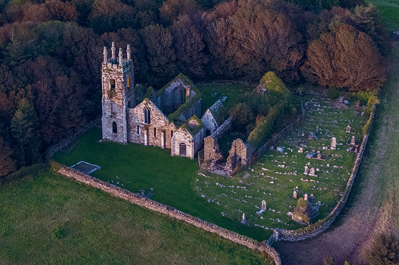
From here follow the track to the ruined churches, where you will first encounter the 19th-century Church of Ireland church, built in a more ornate style than many of the Board of First Fruit churches of its time. This was due to a substantial contribution from Lord Carbery.
Close by is a much older church, with 13th-century features, now in a state of advanced dilapidation. The graveyard and older church contain gravemarkers and tombs mainly of 19th- and 20th-century date, with the earliest being that of Sir Ralph Freke, who died in 1717.
Returning to the trail, watch out on your left for a ringfort or ‘ráth‘, formed by a high circular bank, which is visible through the reeds in the adjacent field. At the little wooden bridge turn right, eventually rejoining the track by the stream to return to the carpark.
This point of interest is, unfortunately, no longer extant. Its name derives from the fact that horse riders had to jump over the bar to continue on this route.
By doing so, they had a more direct route from Castlefreke Country House to the farmyard at Rathbarry Castle and to the church. The former position of the leaping bar is now roughly marked by a Coillte barrier.
This graveyard contains two churches. The larger was built in the 1820s and is uncharacteristically ornate for a Protestant church of this date.
This was due to a considerable contribution by Lord Carbery. The church features a three-storey pinnacled tower and mosaic of religious motifs in the chancel. Lord Carbery and his family had their own entrance and seat on the northern side of the church. It closed for worship in 1927.
Nearby is an earlier, pre-Reformation church, with a 13th-century triple-lancet window at the east end. Documentation from c.1229 indicates David de Barry as the probable patron. The church was extended west in the later medieval period, and recent excavation revealed a 17th-century tower there. A mausoleum was built between the two churches some time after 1841.
The graveyard and earlier church contain gravemarkers and tombs of mainly 19th- and 20th-century date, with some 18th-century examples, the earliest being that of Sir Ralph Freke, who died in 1717. The medieval graveyard is still open for burials.
On the way down from the graveyard, watch out on your left for a ráth or ringfort. Its high banks are visible through the reeds in the adjacent field.
Ringforts were typically constructed between 600 and 900 AD and operated as high-status residences and/or farmsteads.
In the early modern period, Irish people referred to these sites as ‘fairy forts’. Local tradition has it that there was gold in this ‘fairy fort’, yet nobody dared search for it for fear of suffering the wrath of the ‘little people’. (No public access.)
![]()
This is a farming area, so please keep dogs under control at all times. Do not allow them to stray off the tracks, and please clean up dog litter.
In case of emergency please call 999 or 112.
| Cookie | Duration | Description |
|---|---|---|
| cookielawinfo-checkbox-analytics | 11 months | This cookie is set by GDPR Cookie Consent plugin. The cookie is used to store the user consent for the cookies in the category "Analytics". |
| cookielawinfo-checkbox-functional | 11 months | The cookie is set by GDPR cookie consent to record the user consent for the cookies in the category "Functional". |
| cookielawinfo-checkbox-necessary | 11 months | This cookie is set by GDPR Cookie Consent plugin. The cookies is used to store the user consent for the cookies in the category "Necessary". |
| cookielawinfo-checkbox-others | 11 months | This cookie is set by GDPR Cookie Consent plugin. The cookie is used to store the user consent for the cookies in the category "Other. |
| cookielawinfo-checkbox-performance | 11 months | This cookie is set by GDPR Cookie Consent plugin. The cookie is used to store the user consent for the cookies in the category "Performance". |
| viewed_cookie_policy | 11 months | The cookie is set by the GDPR Cookie Consent plugin and is used to store whether or not user has consented to the use of cookies. It does not store any personal data. |