


![]()
This is a farming area, so please keep dogs under control at all times. Do not allow them to stray off the tracks, and please clean up dog litter.
In case of emergency please call 999 or 112.
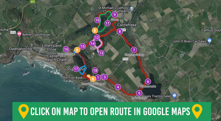
Colour Code: Red
Start/Finish:
Long Strand Carpark
GPS: 51.560824, -8.975996
Distance: 8km / 6km
Duration: 2.5hrs / 1.5hrs
Grade: Moderate
Ascent: 160m
Colour Code: Green
Start/Finish:
Castle Cross Carpark
GPS: 51.571743, -8.975350
Distance: 1.6km
Duration: 40min
Grade: Easy
Ascent: 45m
Colour Code: Purple
Start/Finish:
Castle Cross Carpark
GPS: 51.571743, -8.975350
Distance: 1.7km
Duration: 40min
Grade: Easy
Ascent: 30m
Colour Code: Blue
Start/Finish:
Croaghna Wood Carpark
GPS: 51.567340, -8.981764
Distance: 2km
Duration: 40min
Grade: Moderate
Ascent: 50m
Built in the 15th century by a branch of the Barry family, it was brought under English control following the Battle of Kinsale in 1601.
The castle was leased to Arthur Freke in 1618. It withstood an attack by 400 rebels during the Irish Confederate War of 1641, when it endured the longest siege in Irish history (239 days). Held again by the Irish briefly in 1642, it was soon restored to Freke ownership. The castle was seriously damaged by fire in 1690, during the Williamite War. (No public access.)
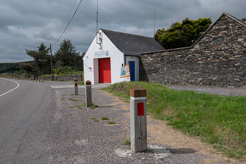
Built pre-1900 as a lifesaving station, it is still used by the local unit of the Irish Coast Guard. Its unusual name bears testimony to the former presence of a rocket launcher.
This device was used in conjunction with a breeches buoy during the station’s early years when rescuing people from vessels run aground or wrecked close to shore.
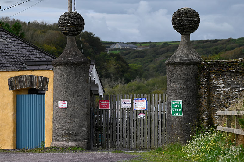
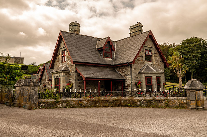
Built c.1820, this gate lodge is sited at the entrance to Rathbarry Castle, which had been converted for use as a farmyard for the Castlefreke estate around this time.
The function of the lodge was to control entry to the farmyard. The building retains many of its original features including its fine slate roof and timber bargeboards at the porch, while its status is enhanced by the adjoining gate piers with their large stone ball finials. (No public access.)
Long Strand’s curving barrier of sand stretches for almost 2km. Tradition has it that the dunes were formed by a tsunami in 1755.
This tsunami was caused by the Lisbon Earthquake. The foredunes were once mobile but have now been fixed under marram grass (Ammophila arenaria). However, erosion has increasingly become a problem as a result of trampling and winter storms.
The old Irish name for the western section of the strand is ‘An Cuar Leathan’ (The Wide Curve) and the eastern section was known as ‘An Cúl Tráigh’ (The Back Strand).
This attractive stone-built cottage can be seen at the end of the lane if you divert a short distance to the right when you reach the lakeshore.
Built c.1870, it was used as a summer residence by Lord and Lady Carbery of Castlefreke Country House.
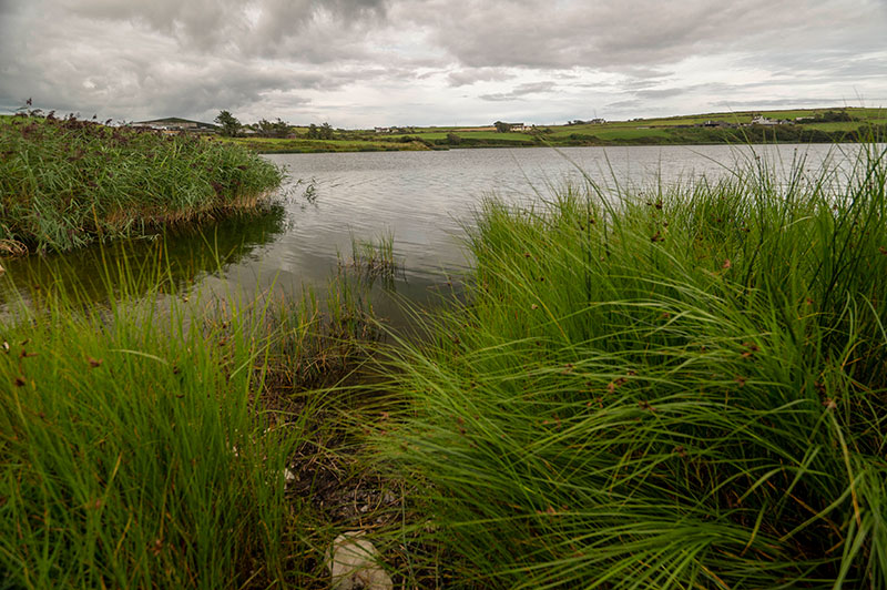
Once a trout fishery, it is the best example of a sedimentary lagoon in southwest Ireland and is also part of a Special Area of Conservation (SAC).
Its connection with the sea at the eastern end of Long Strand, however, is often blocked as sand is shifted southeast by the prevailing wind and tide. Due to a combination of factors, its water quality has deteriorated. A recent survey recorded only three species of fish: eel, stickleback and grey mullet.
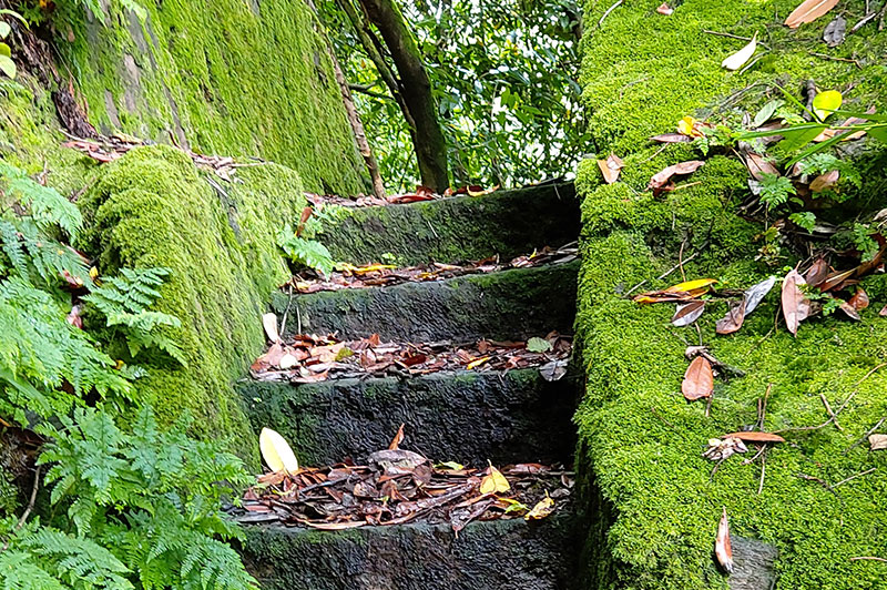
Rock-cut steps lead to a raised platform, where Castlefreke Country House residents and their guests came to shoot waterbirds as they flew over the wetlands below.
This platform would probably have acted as a hide to camouflage shooters, who would have had a good view to the swampy tree thickets across the stream. This may have been constructed in the period when Mary Carbery’s son, John, was resident in the castle, in the first two decades of the 20th century, as he was recorded as an avid shot. The quarry would have been teal and mallard ducks, which were very plentiful before the loss of habitat in the last quarter of the 20th century, due to the expansion of agriculture.
A late Victorian domestic Gothic Revival style construction, it was built in the 1840s by Lord Carbery as a gate lodge to Castlefreke Country House.
The building retains many early features, including its two tall imposing chimneystacks, high-pitched roof and decorative bargeboards. Built of rubble limestone (still exposed), it has quoins at the corners of the walls and squared sandstone window surrounds with hood mouldings over upper windows.
The duty of its occupants was to control entry to Castlefreke demesne. Lady Carbery used to ring a bell on her carriage when she was approaching Castlefreke to summon the gatekeeper to open the gate.
Local tradition has it that stones from this quarry were used for building the high walls that once surrounded the entire Castlefreke demesne.
An example of this impressive stonework can be seen close to Rathbarry/Milltown Roman Catholic church.
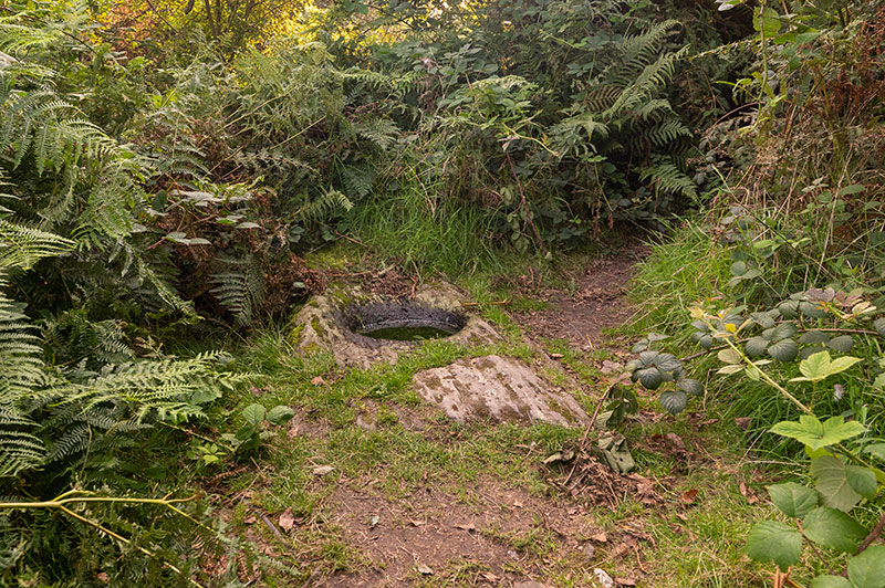
A short distance off the trail is an interesting monument: a rock outcrop with an oval hollow. It is possibly an early medieval bullaun stone.
Bullauns are an archaeological monument-type dated to the 5th–12th centuries AD. They are often associated with ecclesiastical sites of this period, but there is no such site close by. The word bullaun is derived from the Irish ‘ballán’ or ‘bullán’, which refers to round holes in rocks, usually filled with water. Its local name ‘Wart Well’ may indicate later beliefs in its medicinal properties.
It accommodated the head gardener and his family at the Castlefreke estate until 1921. Vegetables, fruit and flowers were grown in the adjacent walled garden.
The last head gardener on the estate was Alfred Jenkins, who was considered to be a ‘great bee man’ by Lady Carbery. (No public access.)
This point of interest is, unfortunately, no longer extant. Its name derives from the fact that horse riders had to jump over the bar to continue on this route.
By doing so, they had a more direct route from Castlefreke Country House to the farmyard at Rathbarry Castle and to the church. The former position of the leaping bar is now roughly marked by a Coillte barrier.
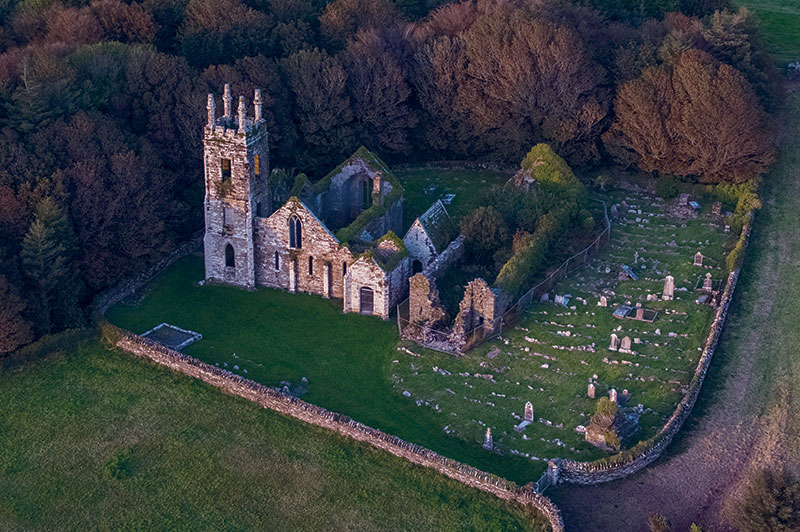
This graveyard contains two churches. The larger was built in the 1820s and is uncharacteristically ornate for a Protestant church of this date.
This was due to a considerable contribution by Lord Carbery. The church features a three-storey pinnacled tower and mosaic of religious motifs in the chancel. Lord Carbery and his family had their own entrance and seat on the northern side of the church. It closed for worship in 1927.
Nearby is an earlier, pre-Reformation church, with a 13th-century triple-lancet window at the east end. Documentation from c.1229 indicates David de Barry as the probable patron. The church was extended west in the later medieval period, and recent excavation revealed a 17th-century tower there. A mausoleum was built between the two churches some time after 1841.
The graveyard and earlier church contain gravemarkers and tombs of mainly 19th- and 20th-century date, with some 18th-century examples, the earliest being that of Sir Ralph Freke, who died in 1717. The medieval graveyard is still open for burials.
On the way down from the graveyard, watch out on your left for a ráth or ringfort. Its high banks are visible through the reeds in the adjacent field.
Ringforts were typically constructed between 600 and 900 AD and operated as high-status residences and/or farmsteads.
In the early modern period, Irish people referred to these sites as ‘fairy forts’. Local tradition has it that there was gold in this ‘fairy fort’, yet nobody dared search for it for fear of suffering the wrath of the ‘little people’. (No public access.)
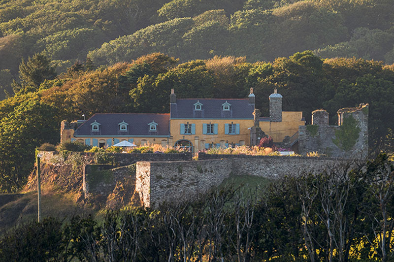
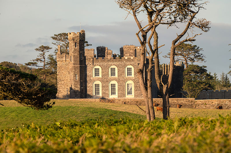
This country house (or castle) was built c.1790 by Sir John Evans-Freke to replace his earlier residence, the nearby 15th-century Rathbarry Castle.
Labourers who were working on the estate found an early medieval hoard of coins close to the house in 1799. These coins, which bore the names of Anglo-Saxon kings, were dated to the 10th century.
In the 1820s, the house was transformed by adding castellations, bartizans, castellated towers, a gateway and a portcullis. It was rebuilt in 1910 following a fire, but in 1919 it was put up for sale by the 10th Lord Carbery, at which point it ceased to be a residence. Instead, it was used for social events and by organisations such as the Irish Defence Forces and the Irish Countrywomen’s Association. (No public access.)
Built c.1830 by Lord Carbery, this former gate lodge retains much of its original form, character and features. It displays fine craftsmanship throughout.
The early features preserved include rubble limestone walls, a canted bay window to the south, and a fine slate roof with rubble stone chimneystacks and timber bargeboards.
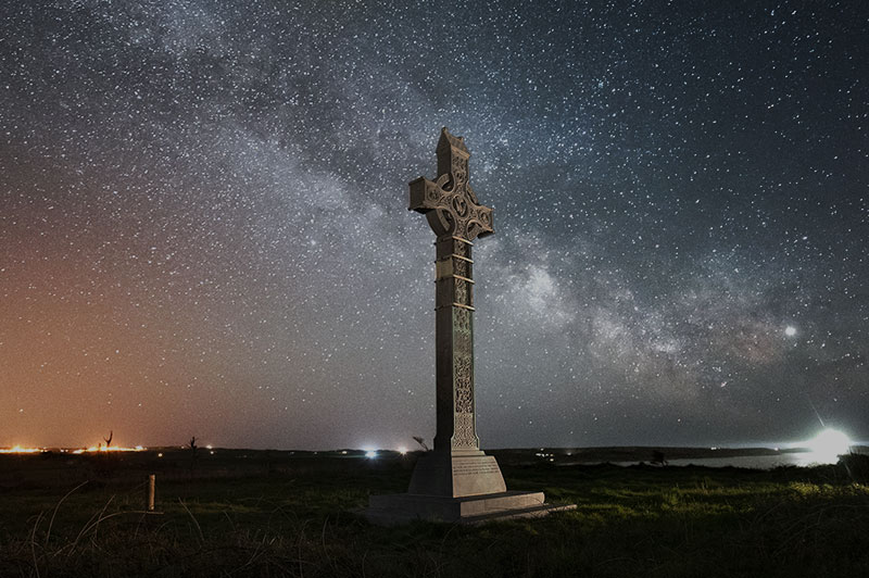
Lord Carbery’s high cross, the tallest memorial cross in Ireland at 9m (30ft), was erected in 1901 as a memorial to Algernon, Lord Carbery.
This Gaelic Revival-style cross was commissioned by his widow, Mary, Lady Carbery.
Carved in three sections, it features scenes illustrative of the Redemption, together with likenesses of St Patrick and St Fachtna. It is enriched with carvings representing angels, passion flowers, scallop shells, animal heads, winged griffons, Irish deer, wolfhounds and various birds, as well interlacings.
This coastal lagoon, along with Castlefreke dunes, is a designated Special Area of Conservation (SAC) because of its key habitats and wildlife.
It once had a navigable channel, now diverted into a culvert, which flowed from Rathbarry Castle to Long Strand.
No posts were found for provided query parameters.
![]()
This is a farming area, so please keep dogs under control at all times. Do not allow them to stray off the tracks, and please clean up dog litter.
In case of emergency please call 999 or 112.
| Cookie | Duration | Description |
|---|---|---|
| cookielawinfo-checkbox-analytics | 11 months | This cookie is set by GDPR Cookie Consent plugin. The cookie is used to store the user consent for the cookies in the category "Analytics". |
| cookielawinfo-checkbox-functional | 11 months | The cookie is set by GDPR cookie consent to record the user consent for the cookies in the category "Functional". |
| cookielawinfo-checkbox-necessary | 11 months | This cookie is set by GDPR Cookie Consent plugin. The cookies is used to store the user consent for the cookies in the category "Necessary". |
| cookielawinfo-checkbox-others | 11 months | This cookie is set by GDPR Cookie Consent plugin. The cookie is used to store the user consent for the cookies in the category "Other. |
| cookielawinfo-checkbox-performance | 11 months | This cookie is set by GDPR Cookie Consent plugin. The cookie is used to store the user consent for the cookies in the category "Performance". |
| viewed_cookie_policy | 11 months | The cookie is set by the GDPR Cookie Consent plugin and is used to store whether or not user has consented to the use of cookies. It does not store any personal data. |